Tsunami Damage Focused on Noto Peninsula’s East Coast; Experts Say Ground Lift May Have Created Protective Barrier

Homes that were inundated by tsunami on the eastern coast of Suzu, Ishikawa Prefecture, are seen from a Yomiuri Shimbun aircraft on Jan. 6.
16:20 JST, January 11, 2024
Damage caused by the tsunami triggered by the Noto Peninsula Earthquake was concentrated on the peninsula’s east coast, while ground uplift appears to have created a barrier that mostly protected the northern coast, according to experts.
The tsunami, which may have measured more than 3 meters in some places, barreled ashore soon after the Jan. 1 earthquake, causing fatalities and forcing some residents to endure extended stays in evacuation shelters.
The extent of the tsunami and other details are gradually coming to light through intensive analysis by experts, which could provide valuable lessons ahead of any future tsunami disaster.
When viewed from a Yomiuri Shimbun aircraft on Jan. 6, the devastation along the peninsula’s coast was impossible to miss. Wreckage of homes that were dragged out to sea by a powerful backwash and other debris littered the eastern coastlines of Suzu and the town of Noto in Ishikawa Prefecture.
The situation was quite different in Wajima and elsewhere along the peninsula’s northern coast. Although it was not possible from the air to confirm any evidence that tsunami had come ashore in these places, the ground had risen significantly over a wide area and swaths of the seafloor were exposed along this coast.
These findings surprised Chuo University Prof. Taro Arikawa, a coastal engineering expert. “The damage was limited to smaller areas than I expected,” said Arikawa, who was on the Yomiuri Shimbun aircraft. “I suspect the tsunami may have reached heights of up to 5 meters in some places.”
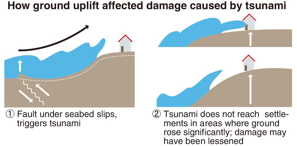
A Geospatial Information Authority of Japan analysis of aerial photos revealed that tsunami inundated a total of about 240 hectares of land, all of which was along the peninsula’s east coast facing Toyama Bay. Ground uplift triggered by the earthquake is thought to be one factor behind the differing levels of tsunami damage sustained by the eastern and northern coasts.
According to sources including data from the Japan Aerospace Exploration Agency’s Daichi-2 Earth observation satellite, the ground surface rose by up to 4 meters in parts of Wajima and elsewhere, and more than 200 meters of new coastline was exposed. Experts believe this newly created topography acted as a natural breakwater that blocked tsunami from flowing further ashore.
“Even if tsunami arrived there, it seems they didn’t reach any settlements,” said Hiroshima University Associate Prof. Hideaki Goto, a geography expert.
By contrast, ground on the eastern coast of Suzu rose by only about 25 centimeters, so tsunami swamped settlements there virtually unimpeded. Many residents were caught off guard by the arrival of tsunami so soon after the powerful earthquake, which measured the maximum 7 on the Japanese seismic intensity scale. “A fishing boat rose up into the air at the same time as the tsunami passed,” one frightened local recalled. It appears that the level of ground uplift varied depending on factors including the underground structure of the fault, but this difference also influenced the extent of damage inflicted by tsunami.
Over 3 meters?
Data transmissions from Japan Meteorological Agency observation points in the region were interrupted after the quake. Consequently, the precise heights and arrival times of tsunami at locations near the epicenter remain unknown.
However, computer analysis and on-the-ground checks by experts and other research has shed light on some of these details. For instance, it has been learned that tsunami arrived at locations close to the epicenter, such as Suzu, about one minute after the earthquake struck; tsunami featured second and third waves, and that a 3.6-meter tsunami lashed the peninsula’s east coast several tens of minutes after the temblor. Also, tsunami about 2 meters high also were recorded in the town of Shika on the peninsula’s west coast and in Niigata Prefecture.
The region’s distinctive seafloor topography is thought to be one reason why large tsunami tended to concentrate on the peninsula’s east coast. A relative shallow shelf stretches out from near the eastern coast, but the water further offshore is deep. A tsunami moves faster in deeper water and slower in shallower water, so it is possible the tsunami wrapped around the shelf and became focused on locations such as Suzu and Noto on the eastern coast.
Experts also believe that faster tsunami caught up to and absorbed preceding tsunami, making them even bigger.
Data that emerged from Toyama City also has intrigued experts. A tsunami was recorded in Toyama immediately after the earthquake happened, despite the city being a considerable distance from the epicenter. It is highly likely that the initial strong shaking triggered a landslide on Toyama Bay’s seafloor, which generated a separate tsunami from the one sparked by the temblor.
Seafloor landslides could happen in wide areas under the waters around Japan, so evacuating without delay is necessary even in locations distant from an earthquake’s epicenter.
Tohoku University Prof. Fumihiko Imamura, an expert on tsunami engineering, said lessons must be learned from this disaster.
“Tsunami like these could also occur when a massive earthquake strikes in the Nankai Trough,” Imamura warned. “As well as urgently evacuating, people should be prepared for second and additional tsunami, and they should also think about a ‘secondary evacuation’ to safer, higher ground.”


Most Read
Most read in the last 24 hours
-

Stepfather Reportedly Admits to Killing 11-Year-Old Boy Who Went ...
-

Dead Boy's Stepfather Confessed to Killing, Police Say; Victim's ...
-

Japan’s Coffee Bean Production Looks to Northern Areas to Expand ...
-

4 Injured as Pipe Bursts at Semiconductor-Related Company’s Facto...
-

Osaka Tax Official Leaks Data to Scammers Impersonating Police Of...
-

Cherry Blossoms in Full Bloom Across Iwate Prefecture, Bringing S...
-

Sexual Abuse Allegations Are Spurring Calls for a Broader Reckoni...
-

Stable Imperial Succession: Debate the Issue without Excluding Fe...
Most read in the last 7 days
-
Police Find Child's Shoe During Search for Missing Boy in Nantan,...
-

Body Found in Nantan, Kyoto Prefecture, During Search for 11-Year...
-

Japanese Prime Minister Takaichi Speaks to Pakistani Prime Minist...
-

Kyoto Police Arrests Father of 11-Year-Old Boy on Suspicion of Ab...
-

Body Found in Kyoto Pref. Forest Confirmed to Be Missing 11-Year-...
-
Strong Typhoon Sinlaku Heading Toward Tokyo's Ogasawara Islands
-

No Clear Plan for Expo Site 6 Months After Close; Delays, Unpaid ...
-
Stepfather Reportedly Admits to Killing 11-Year-Old Boy Who Went ...
Most read in the last 30 days
-

Mathematician Heisuke Hironaka, Winner of Fields Medal, Dies at 9...
-
Police Find Child's Shoe During Search for Missing Boy in Nantan,...
-
Body Found in Nantan, Kyoto Prefecture, During Search for 11-Year...
-

Cherry Blossoms, Rapeseed Flowers Perform Colorful ‘Duet’ in Niig...
-

New Bird Species Confirmed in Japan for 1st Time in 45 Years, Fou...
-

Nori Prices Surge in Japan Due to Poor Seaweed Production Amid Ri...
-

Earthquake Jolts Kansai Region, Recording Magnitude 4.2, Japanese...
-

Cherry Blossoms in Full Bloom Draw Crowds in Sendai, Miyagi Pref....
Top Articles in Society
-
Police Find Child’s Shoe During Search for Missing Boy in Nantan, Kyoto Prefecture
-
Body Found in Nantan, Kyoto Prefecture, During Search for 11-Year-Old Boy in Area (Update 1)
-
Cherry Blossoms, Rapeseed Flowers Perform Colorful ‘Duet’ in Niigata
-
New Bird Species Confirmed in Japan for 1st Time in 45 Years, Found on Tokara Islands in Kagoshima Pref.
-
Earthquake Jolts Kansai Region, Recording Magnitude 4.2, Japanese Seismic Intensity Scale 3
JN ACCESS RANKING
-
Police Find Child’s Shoe During Search for Missing Boy in Nantan, Kyoto Prefecture
-
Body Found in Nantan, Kyoto Prefecture, During Search for 11-Year-Old Boy in Area (Update 1)
-
Cherry Blossoms, Rapeseed Flowers Perform Colorful ‘Duet’ in Niigata
-
New Bird Species Confirmed in Japan for 1st Time in 45 Years, Found on Tokara Islands in Kagoshima Pref.
-
Nori Prices Surge in Japan Due to Poor Seaweed Production Amid Rising Sea Temps; Price of Onigiri Rice Balls Also Impacted
Most read in the last 24 hours
-
Stepfather Reportedly Admits to Killing 11-Year-Old Boy Who Went ...
-
Dead Boy's Stepfather Confessed to Killing, Police Say; Victim's ...
-
Japan’s Coffee Bean Production Looks to Northern Areas to Expand ...
-
4 Injured as Pipe Bursts at Semiconductor-Related Company’s Facto...
-
Osaka Tax Official Leaks Data to Scammers Impersonating Police Of...
Most read in the last 7 days
-
Police Find Child's Shoe During Search for Missing Boy in Nantan,...
-
Body Found in Nantan, Kyoto Prefecture, During Search for 11-Year...
-
Japanese Prime Minister Takaichi Speaks to Pakistani Prime Minist...
-
Kyoto Police Arrests Father of 11-Year-Old Boy on Suspicion of Ab...
-
Body Found in Kyoto Pref. Forest Confirmed to Be Missing 11-Year-...
Most read in the last 30 days
-
Mathematician Heisuke Hironaka, Winner of Fields Medal, Dies at 9...
-
Police Find Child's Shoe During Search for Missing Boy in Nantan,...
-
Body Found in Nantan, Kyoto Prefecture, During Search for 11-Year...
-
Cherry Blossoms, Rapeseed Flowers Perform Colorful ‘Duet’ in Niig...
-
New Bird Species Confirmed in Japan for 1st Time in 45 Years, Fou...